Major Landforms and Rivers
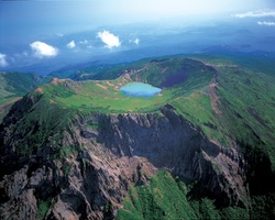
Mt. Halla-san
South Korea lies on the Korean Peninsula, and South Korea mainly consistis of mostly hills and montains, and in the south and west there are coastal plains and multiple small islands. Also to the east there are the Taebaek Mountain Ranges which dominates the lanscape. On the island of Cheju lies the extinct volcano Mt. Halla-san which rise 1,950 meters. Now there are three major rivers in South Korea the Kum, Han, and Naktong river.
Climate Map of South Korea

This is a climate map of South Korea. The purple color in the north means that there is a dry winter. As you move further south, the light green, the climate changes into a dry summer, and where the dark green is one can expect a humid temperate climate.
